 |
 |
 |
|
SeaPro Plus - PC Charting & Navigation Software
Advanced Tracking & Navigation System!
The advanced seaPro Plus offers all the features of seaPro
Standard plus a host of additional functions designed to meet the
needs of those sailing further afield.
seaPro Plus is typically fitted to the smaller commercial patrol or
harbour craft / offices and many "blue-water" yachts, offshore racers,
powerboats and motor yachts.
seaPro plus supports the ARCS Navigator raster chart service (with
its weekly update facility) and also ENC (S57) vector chart service
for both UKHO and Primar chart suppliers (available through
LM).
SeaPro Plus - The advanced navigation system.
|
Setup & Operating
|
- Simple set up - Just connect your GPS to the serial port of your PC to see your vessels position on the chart.
- Folio Mode - Charts may be selected manually or you can allow the system to choose the appropriate charts for you.
-
Route Planning and Monitoring - Position way-points easily by clicking the mouse button or edit them manually for precise positioning. 'On Route' information includes bearing and distance to next waypoint. All routes can be saved and re-used as required.
- Extended Track Line - Shows your boat's position at 30 and 60 minutes based on current speed and course.
- Flashing light sequences. (on vector charts as available)
-
Multiple chart windows - Plan and monitor your passage in different windows at different levels of zoom. Alternatively monitor
your position in one window while planning your passage in another.
- Overzoom - This feature allows the user to zoom into a chart beyond the normal viewing level.
- Multiple Overlays & Databases - This feature allows multiple overlays and databases to be displayed simultaneously.
|
|
Add-ins
|
- Uses high quality Livechart vector charts - Livecharts are mainly derived directly from S57 data provided from the Hydrographic offices - so no problems of manual digitization from paper charts.
- seaPro lite+ support for muliple chart formats including S57, both encrypted (AVCS, Primar, Australian HO) and unencrypted cells, raster formats such as BSB/BSB4. Seamless changes between the different formats - allow seaPro lite+ to
automatically choose the best scaled.
- Navionics chart option - with this 'add on' use your own Navionics charts (Gold and Platinum) - currently not available.
- Tidal Curves - view the tidal heights for most of the major and minor ports in the world. (requires purchase of optional tidal database)
-
Built in support for multiple chart types both vector and raster
BSB,Livechart and the new official S57 data (option). Seamless
change between the different formats - allow seaPro to
automatically choose the best scaled chart for you.
-
Tidal passage planning - Using tidal data from official sources,
where available, seaPro will calculate passage time, expected
ground track, course to steer and best departure time. You can also
enter your own tidal diamonds.
-
Tidal streams - Where available, visual tidal vectors can also be
displayed on the chart or can be manually entered.
-
Weather information download GRIB weather files and display the
weather patterns over your charts -wind, presure, wave height,
temperature etc. ( depends on the source of your weather information).
Use the GRIB weather data when automaticaly calculating your
passage plan (weather routing)
-
Weather routing - For sailing yachts, planning is made even
easier. Using information on your yachts sailing performance
(polar diagram), tidal data and predicted wind (from a GRIB
weather file or manually entered) seaPro will calculate the best
route either between two points or from your route, adding tacking
points as required making best use of wind and tide. If you have
more than one sail plan you even get suggestions when to
change sails.
|
|
Tools
|
- Chart zoom & panning tools - move around charts quickly and easily.
- Measure Tool - Measure distances and bearings quickly.
- Dockable Toolbars - Place your toolbars where you need them, either on the chart or neatly stowed at the top or bottom of the screen.
- Chart Overlay - add your own marks, text, lines,areas for favorite fishing,anchoring or diving sites etc.
-
Fuel calculations - For the powerboat and motor yacht
owner, this feature gives estimated fuel consumption when
planning a route.
-
Instrument Panel - Interfaced to your instruments via
NMEA0183, seaPro will display this information in the repeater
panel. (position, log, wind speed & direction, depth, heading &
temperature)
-
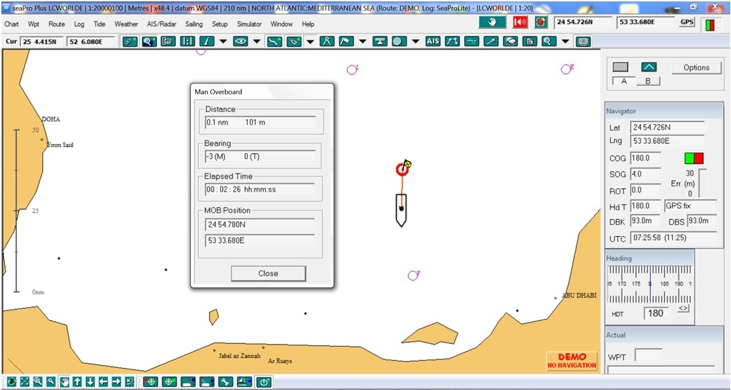
Position & Track Logging - GPS data is automatically written to
the log at predetermined intervals and can be replayed or
reviewed at a later date. Drop different 'marker flags' to indicate
'man overboard' or points of interest into the log with a single
press of a button.
-
Log Playback/animation of previous own vessel log.
-
Polar diagrams - The wind/speed performance characteristics of
a sailing yacht can be entered and updated. This is then
displayed graphically as a polar diagram and enables you to
determine the maximum boat speed achievable for a given wind
speed and wind angle.
-
Voice output - The voice output feature will keep you updated on
your vessels speed, heading and progress along your route at
either fixed time intervals or when the information changes.
(English version only)
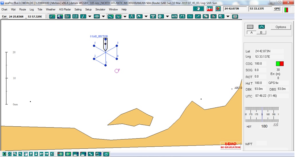
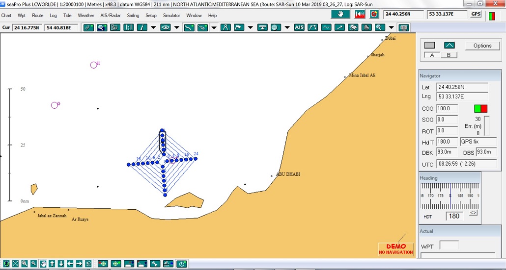
- Search & Rescue - Create standard SAR patterns taking tidal information into account.
- Chart corrections - This function allows you to undertake your own chart corrections on both vector and raster charts.
- Great circle planning - This makes planning an ocean passage very simple. Just put a waypoint at the start and finish of your route and seaPro will fill in the rest giving you a great circle track.
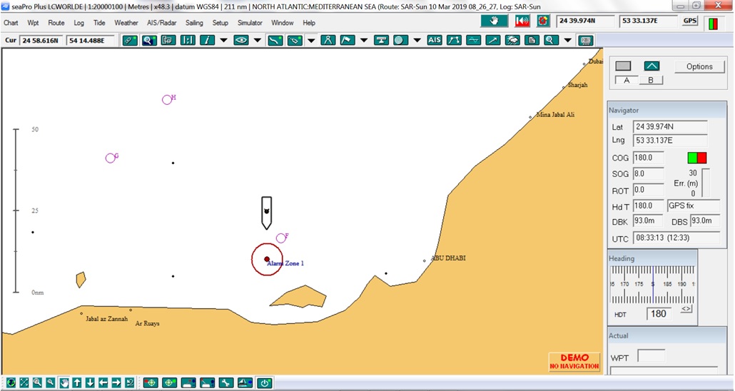
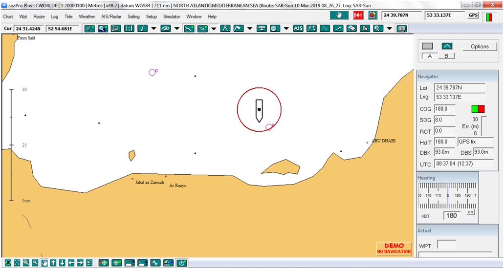
- Advanced zone alarms - Set multiple alarm zones using polygon, rectangular or circular areas. Control what triggers the alarm, leaving or entering the alarm zone etc.
- Enhanced logging - Any supported incoming instrument data can be logged. The user can determine the intervals at which this information is recorded.
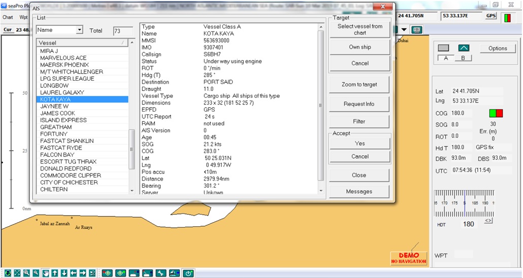
- UAIS enhanced features - new target acceptance option and adding of own track id's or comments such as berthing information (port control) etc. to AIS targets
- Display previous track concurrently with active track -for repeating a known safe navigation passage.
- Other features of seaPro Plus include animated log-replay - own vessel and targets (AIS and ARPA), instrument log graphs, gyro interface and multiple NMEA interfacing.
- Enhanced overlay facility - ideal for wreck and mini-survey usage
- Blank chart sheets - for very large scale mapping - ideal for diving, wreck hunting and min-surveys
|
|
Interfacing
|
- AIS - when connected to an AIS receiver or AIS transponder (class A or B) see information on other AIS equipped vessels (General AIS information).
- NAVTEX - support for the dual frequency NAVTEX receiver gives free Marine weather forecasts and other information.
- Autopilot Control - Once a route has been created, information can be sent to the NMEA0183 compatible autopilot allowing it to steer to each waypoint.
- GPS - Support for multiple serial ports or GPS/AIS data via a wired/wireless ethernet connection (TCP/IP).
-
PC Radar interface - display radar overlay images on the chart,
plus full control of the radar from within seaPro - requires Koden
Radar PC.
-
ARPA radar interface - display radar targets overlayed on the
chart, with extended track line and information on Close Point of
Approach (CPA/TCPA) etc. when interfaced to a suitable
ATPA/MARPA radar with NMEA 183 output.
- Network Installation - An additional option for seaPro Plus, the network installation allows multiple users to share charts and instrument data
- Act as a NMEA server, distributing NMEA 183 data (GPS instruments, ARPA data etc) across a TC/IP network or across the internet.
- Act as a route server, distributing current route across a TC/IP networkt. Changes will be updated on other seaPro plus computers
|
|
|
|
|
Enhanced AIS
|
Advanced Alarm Zones
|
Guard Zones
|
|
|
|
|
MOB Features
|
Search & Rescue Features
|
SAR Features
|
- Windows PC Software.
- Compatible with Windows 7, 8.1 and 10.
|
|
Minimum System Requirements
|
Recommended
|
S57
|
Operating System
(Note 1)
|
Windows/XP/Vista//Win 7,8.1 and Windows 10
|
Windows 10
|
Windows 7/10
|
|
Processor
|
I3 or I5 1.8
GHz
Note:Lower spec such as Atom/Celeron will work but slowly.
|
I3 or I5 1.8GHz or
better
|
I5/I7 2.0GHz or
better
|
RAM
(Note 2)
|
4 GByte (512 MBytes
XP)
|
4 GByte or more
|
4 GByte or more
|
|
Free Hard Disk Space
|
5 GByte - Amount
depends on number of charts required and type
|
Solid State disk
(SSD) drive recommended
|
SSD drive
|
Serial Ports
(Note 3)
|
1 x (or USB to serial
converter)
|
|
|
|
USB Ports
|
1 x for security
dongle
|
|
|
Graphics Display
(Note 4)
|
1024x600 16bit colors
|
1024x758 or better
accelerated graphics card
|
Accelerated graphics
chip either separate of built into a modern processor.
|
|
Miscellaneous
|
Internet conection
for downloads/updates (can use USB drive instead)
DVD drive is not normaly required unless taking ARCS/S57chart data on
CD/DVD
|
|
|
Note 1: Windows XP - This operating system is no longer supported by Microsoft, so continued operation can't be guaranteed. Whichever operating system is being used, its presumed that the latest service
packs have been applied plus any other appropriate updates/patches (for XP this
means SP3 and for Vista SP2).
Note 2: Whichever operating system is being used, its presumed that the latest service
packs have been applied plus any other appropriate updates/patches (for XP this
means SP3 and for Vista SP2).
The minimum level depends on your operating
system requirements. For example XP will work with 512 MBytes, Vista should
have at least 1GByte. If your computer is suitable for the specified operating
system then it should be fine with seaPro - More memory is better.
Most modern computer\laptops will meet the specifications for all of the above.
Note3: Most laptops don't have a serial port,so
add a USB/serial converter if GPS input required. Alternatively use TCP/IP
input (via converter). Some equipment such as USB AIS unit have a driver that
installs a virtual serial port.
Note 4: At 1024x 600 resolution (as used on Netbooks)
the important dialog will operate correctly, some advanced features may
require slight scrolling.
Note 5:seaPro
will work with both 32 and 64 bit Windows operating systems. A dual 32/64 bit
dongle driver is supplied.
The above are recommended minimums especially with S57 and 3D, higher specifications will mean your PC will also work better with other/more applications and extend its useful life.
|
|
|
 |
|
 |
|
|
|
 |
|
 |
|
Features & Benefits
- All features of SeaPro Lite and SeaPro Standard, including Simple Set Up, Shows Vessel Chart Position Real-time, Easy Route Planning & Monitoring, Full Autopilot Control, Extended Track Line, Navtex Interface & Data Display, GPS Interface & Data Display, AIS Interface & Data Display, Range & Bearing Measure Tools, Chart Overlay (own marks, text, lines, areas), Tidal Curve Functions (Heights), Vector Chart Format inc Livecharts, Raster Chart Formats, Multiple Chart Windows, Built-in Support for Multiple Chart Types, Tidal Passage Planning, Tidal Streams, PC Radar Interface, ARPA Radar Interface, GRIB Weather Information, Fuel Calculations, Instrument Panel, Position & Track Logging, Log Playback/animation, Polar Diagrams, Weather Routing, Voice Output
- Search & Rescue (SAR) functions
- Overzoom
- Multiple Overlays & Databases
- Chart Corrections
- Great Circle Planning
- Advanced Zone Alarms
- Enhanced Logging
- AIS Enhanced Features
- Display Previous Track
- Network Installation (option)
- Animated Log Replay (Own Vessel & Targets - AIS and ARPA)
- Enhanced Overlay Facility
- Blank Chart Sheets
- NMEA Server
- Route Server
|
|
|
|
|
|
|