|
 |
 |
|
SeaPro Patrol - Electronic Chart System
Patrol & Enforcement - Protecting Your Resources!
SeaPro Patrol is a powerful navigation system, which provides logging and reporting
functions for enforcement and similar operations. The seaPro Patrol & Enforcement System offers worldwide functionality through use of the following high quality raster and vector electronic charting formats: Livechart B’ - ARCS - BSB – Seafarer and S57.
Euronav has developed the Patrol & Enforcement System after working closely with several government departments. As well as providing sophisticated navigation functions using official hydrographic charts, the system allows patrol units to easily log
vessel sightings and to record boardings, offences etc. which may have been committed by sighted vessels. The system is ideal for use in Coastal patrols and home land security, Immigration control, Coastguard operations, Customs & Excise operations, Surveying – Oil & Gas and minerals, Offshore guard & safety support, Fishery protection operations, Environmental research and other resource management/protection schemes.
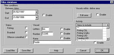
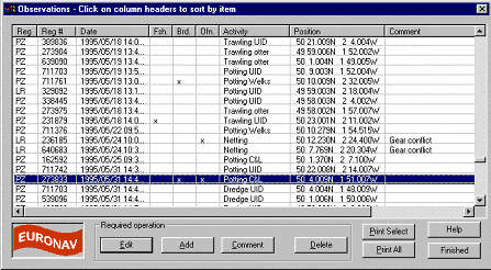
Recording a vessel sighting is accomplished easily and simply with a single mouse-click on the chart (this could be over an ARPA radar target shown on the screen, an AIS target. or a measurement bearing). The system presents the user with a dialog box, pre-filled with the date and time of the sighting and the sighted vessel’s position. The user then records the details of the sighted vessel’s activities along with any comments. The system will also store image files (e.g. from a digital camera) associated with the sighting.
Vessel sighting data can quickly build-up into large files which may be difficult to visualise on-screen, so seaPro Patrol & Enforcement System provides useful tools to
refine and filter the data viewed. The user can instruct the system to show for example, only vessels which have been boarded, all vessels which have committed an offence between certain dates, or any combination of these factors. During the course of
operational activity, a database is built-up by the system, which can be viewed and sorted in list format as well as graphically on-screen.
Logged data is stored in multiple databases which may be sorted, filtered and queried at will by on-board officers; the data can also be shared with shore based systems. In this way, an enforcement agency can have access to details of all sightings made by all their seagoing assets. These data may then be manipulated within the system, or exported for analysis and display in statistical or reporting software, either for general reporting or in a forensic context.
|
Improved Safety
|
- Real-time Navigation
- 'At-a-glance' Situational Awareness
- Overlay of ARPA radar targets on charts
- Automatic 'Look Ahead' View for maximum clarity
- Weather Overlays
- Chart Corrections via DVD or Internet update
- Data Recording of voyage for incident investigation
- Full AIS compatibility
|
|
Increased Operational Efficiency
|
- Practical Route Planning tools enable passage plans to be quickly calculated or checked.
- Chart can be electronically updated.
- Additional Charts can be 'unlocked' from an on-board CD.
- Routes and Waypoints can be transferred to GPS or Radar to enable them to use the same data.
- Can communicate passage plans, logs, weather data and chart updates via email.
|
|
RealTime Navigation
|
- SeaPro Professional automatically provides the navigator with real-time position of the vessel and other important information for situation awareness, including;
- ARPA Target position and vector information,
- Repeated Data from others sensors including Log and Gyro,
- Projected Position from Heading or Course-Over-Ground,
- Vessel Track,
- Scaled Vessel Outline,
- Rate of Turn Display.
|
|
Look Ahead View
|
- SeaPro provides both Relative Motion and True Motion modes. Relative or 'Look Ahead' mode enables the vessel to remain at a fixed position giving the navigator a clear view ahead of the vessel. In this mode the chart is automatically scrolled in the background allowing true 'hands-free' operation.
- In addition the chart orientation can be set to the following modes;
- North Up,
- Heading Up,
- Route Up.
|
|
Route Planning
|
- SeaPro Professional contains advanced route planning facilities that enable tidal and magnetic variation to be automatically calculated in passage plans. Schedule information including ETA and time-to-go are provided in addition to a print formatted passage plan.
- Route and Waypoint information can also be sent to an Autopilot, GPS and ARPA Radar.
|
|
Integrated Weather Information
|
- Weather Data from various official Meteorological Offices can be delivered via email and animated within SeaPro to show up to 5 day weather forecasts. Information that can be displayed includes pressure, wind speed, wind direction and wave heights.
|
|
Chart Formats
|
- SeaPro is a 'multi-fuel' platform that supports both Raster and Vector Chart Formats to provide the best choice of charts worldwide. Formats include;
- Vector Chart Formats:
- S-57 ENC - Official UKHO and Primar Charts
- Livecharts - Euronav's vector charts.
- Raster Chart Formats:
- ARCS - British Admiralty charts offering worldwide coverage.
- Seafarer - Australian Hydrographic Office charts covering Australasian waters.
- NZ Mariner - New Zealand Charting Authority charts covering New Zealand waters.
- BSB - National Oceanographic & Aeronautical Administration charts covering US waters
|
|
Chart Corrections
|
- Chart update services as frequently as once per week are available depending on chart format and type.
|
|
Options
|
- SeaPro can optionally network to other computers for multiple navigation stations and can also be used as an information repeater for example in the masters or officers cabins or for the Euronav PI3000 Passenger Information System.
|
|
|

|
|
Database Filter
|
Database List Format
|
Filter View
|
|
|
|
|
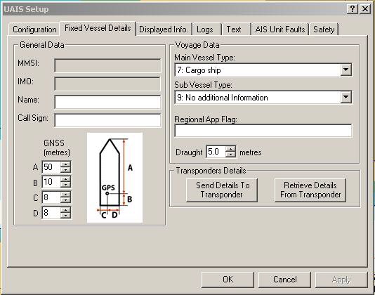
AIS Own Vessel
|
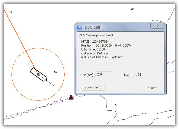
DSC Call
|
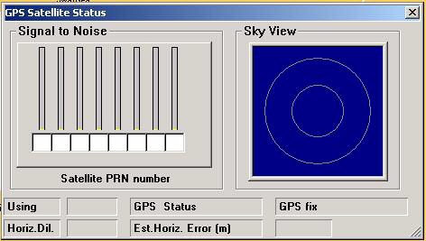
GPS Status
|
- Windows PC Software.
- Compatible with Windows 7, 8.1 and 10.
|
|
Minimum System Requirements
|
Recommended
|
S57
|
Operating System
(Note 1)
|
Windows/XP/Vista//Win 7,8.1 and Windows 10
|
Windows 10
|
Windows 7/10
|
|
Processor
|
I3 or I5 1.8
GHz
Note:Lower spec such as Atom/Celeron will work but slowly.
|
I3 or I5 1.8GHz or
better
|
I5/I7 2.0GHz or
better
|
RAM
(Note 2)
|
4 GByte (512 MBytes
XP)
|
4 GByte or more
|
4 GByte or more
|
|
Free Hard Disk Space
|
5 GByte - Amount
depends on number of charts required and type
|
Solid State disk
(SSD) drive recommended
|
SSD drive
|
Serial Ports
(Note 3)
|
1 x (or USB to serial
converter)
|
|
|
|
USB Ports
|
1 x for security
dongle
|
|
|
Graphics Display
(Note 4)
|
1024x600 16bit colors
|
1024x758 or better
accelerated graphics card
|
Accelerated graphics
chip either separate of built into a modern processor.
|
|
Miscellaneous
|
Internet conection
for downloads/updates (can use USB drive instead)
DVD drive is not normaly required unless taking ARCS/S57chart data on
CD/DVD
|
|
|
Note 1: Windows XP - This operating system is no longer supported by Microsoft, so continued operation can't be guaranteed. Whichever operating system is being used, its presumed that the latest service
packs have been applied plus any other appropriate updates/patches (for XP this
means SP3 and for Vista SP2).
Note 2: Whichever operating system is being used, its presumed that the latest service
packs have been applied plus any other appropriate updates/patches (for XP this
means SP3 and for Vista SP2).
The minimum level depends on your operating
system requirements. For example XP will work with 512 MBytes, Vista should
have at least 1GByte. If your computer is suitable for the specified operating
system then it should be fine with seaPro - More memory is better.
Most modern computer\laptops will meet the specifications for all of the above.
Note3: Most laptops don't have a serial port,so
add a USB/serial converter if GPS input required. Alternatively use TCP/IP
input (via converter). Some equipment such as USB AIS unit have a driver that
installs a virtual serial port.
Note 4: At 1024x 600 resolution (as used on Netbooks)
the important dialog will operate correctly, some advanced features may
require slight scrolling.
Note 5:seaPro
will work with both 32 and 64 bit Windows operating systems. A dual 32/64 bit
dongle driver is supplied.
The above are recommended minimums especially with S57 and 3D, higher specifications will mean your PC will also work better with other/more applications and extend its useful life.
|
|
|
 |
|
 |
|
|
|
 |
|
 |
|
Features & Benefits
- All the features of seaPro Plus or seaPro Professional
- Options available to interface across LAN or internet
- Easy to use at sea
- Can interface to AIS for easy vessel identification of suitably equipped vessels or ARPA radar
- Logging of previous encountered vessels, their previous history, prosecution etc
- Flexible easy to use database system
- Simple text enquiry system, no-need to learn database query languages and graphical display of results on chart
- Uses a standard database format so sophisticated data extraction can be done later at base by technical staff.
- Can act as navigation system or form part of a ship wide navigation and tactical system.
|
|
|
|
|
|
|